
River of Sorrows
Dolores River
The Dolores, or "River of Sorrows" lives up to its name. This high-desert gem, which scenery rivals that of the Grand Canyon, has been tragically de-watered for years on end, thanks to over-allocation for crops that are unsustainable in a desert environment. This has left the lower Dolores below McPhee Reservoir with 40cfs or less most of the year, nearly destroying the habitat for native fish and other wildlife in the canyon. You’ll need to wait for a big snow year to find sufficient flows to boat the Dolores, enough to fill and spill the dam. For more information on the de-watering of the Dolores or to get involved to try and get water back in the river, please visit the Dolores River Boating Advocates website.
-
Season
- April-June
- Usually only runs on seasons when snowpack in the San Juans is above average.
- Gateway-Dewey section is runnable most years because of inflow from the San Miguel.
-
More Resources
- Dolores releases and other up to date information can be found at the Dolores Water “Conservation” District web page.
- The BLM has additional Dolores River information.
Bradfield Launch to Slick Rock
This is generally a two or three-day trip. One-day trips are possible between Bradfield Bridge and Mountain Sheep Point Recreation Site (19 miles). Total trip length from Bradfield Bridge to Slick Rock is 47 river miles.
Shuttle distance is approximately 40 miles/50 minutes one way via paved and gravel roads.
This stretch of river drops an average of 19 feet per mile and contains the most difficult and challenging whitewater on the Dolores River, including “Snaggletooth Rapid” (Class IV-V).
The access point to this segment of the river is the Bradfield Recreation Site on river left 1/4 mile downstream from the Bradfield Bridge.
The Bradfield Recreation Site offers campsites, toilets, potable water, and a gravel-surfaced parking area and boat launch ramp. Campsite fees are $8.00 per night.
Sloping canyon walls covered with oakbrush and other shrubs characterize the first few miles of river below Bradfield Bridge. Then the canyon deepens, sandstone walls appear and groves of ponderosa pine and Douglas fir cover the benches along the river. This stretch of river is appropriately called "Ponderosa Gorge". The unique combination of pine groves and red sandstone cliffs makes this one of the most scenic segments of the Dolores River.
Approximately 19 miles downriver from Bradfield is the Mountain Sheep Point Recreation Site, which can be accessed by driving about 6 miles east from Dove Creek along gravel and dirt county roads. This access site has limited parking, a boat launch ramp, toilets, and limited primitive campsites just down river at the “Box Elder” campsite. No fees are charged for camping here. There is no potable water at this site.
Snaggletooth Rapid (Class IV-V) is located about eight miles below the Mountain Sheep Point Recreation Site near mile 27. This rapid has been portaged as often as successfully run. Stop and scout this rapid (river left).
Below Snaggletooth, the canyon becomes drier and the vegetation begins to change to that of Upper Sonoran life zone. Piñon-juniper, yucca, cactus, and various shrubs are predominant. A few miles above Slick Rock the canyon widens to rolling, arid hills.
Maximum group size 25 persons.
Gauge:
Slick Rock to Bedrock
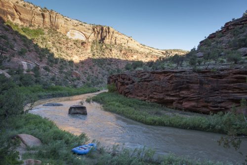
This 50 mile segment of the Dolores a true gem and hosts some of the best scenery on the river. This stretch drops an average of 10 feet per mile with fewer and less difficult rapids than the upper segment, though it still contains several short Class III drops.
World class scenery and camping on the Dolores
The Slick Rock to Bedrock segment is normally run in two or three days. Trip length is 50 river miles or 36 river miles from Gypsum Valley to Bedrock. Shuttle distance from Slick Rock to Bedrock is approximately 60 miles/90 minutes one way via paved roads.
The launch site is a cleared area just east of the Highway 141 Bridge at Slick Rock. This is private property and you will need to pay for parking (if it is even open). Parking directions will be posted. Please cooperate with the owners. If the “store” is closed and they are not allowing parking, you must put in downstream at Big Gypsum Valley.
An alternate put-in is in Big Gypsum Valley, 14 miles downriver or 25 road miles from Slick Rock. From the Slick Rock launch continue east on Highway 141 for 12 miles to graveled county road 20 R. Turn left (west) and proceed 13 miles down 20 R to the Gypsum Valley Recreation Site. Facilities include a launch ramp, parking, picnic tables, grills, and shelters. There are no toilets or potable water at this site. Camping is allowed but is very primitive.
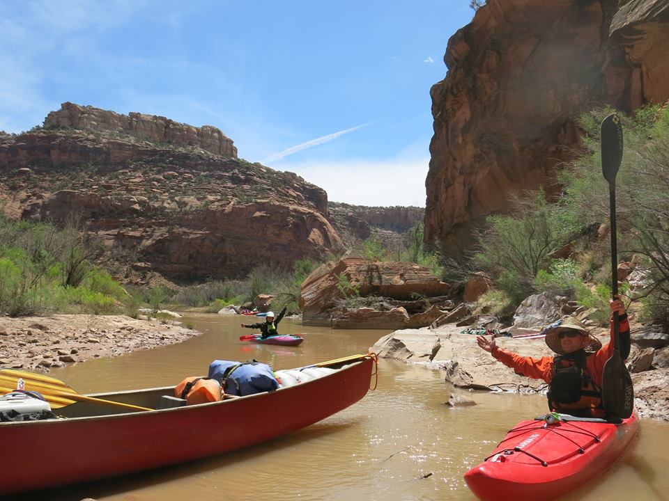
About 16.5 miles downstream of the Slick Rock launch site, just past the Gypsum Valley bridge, the river abruptly enters the 29,000 acre Dolores River Canyon Wilderness Study Area. Here, the Dolores begins a series of meanders deeply entrenched in the massive sandstones of the area. The canyon is narrow and deep with towering walls that often reach skyward directly from the water’s edge. Several large side canyons provide interesting hiking along this segment. Slick Rock Canyon ends abruptly at Bedrock where the river crosses Paradox Valley.
The Bedrock access is just south and west of the Bedrock Bridge. Facilities include a launch ramp, parking, picnic tables, grills and shelters. There are no toilets or potable water. Camping is allowed but is very primitive.
Maximum group size 16 persons.
Gauge:

Gateway, CO to Dewey Bridge, UT
This stretch is one of the least run, yet most accessible stretches of the Dolores River. Thanks to the San Miguel river, which spills into the Dolores upstream of Gateway, this stretch is runnable almost every spring, compared to the stretches upstream that are lucky to run once ever 5-10 years.
Awesome hiking and scenery on the Lower Dolores
Most of this 32 mile stretch is flat, with 3 exceptions. Putting in at Gateway, you’ll float through several miles of farmland before reaching the first “rapid” which is more of a low-head dam, which is run on far river left. After this the gradient picks up to some well-spaced Class II boogie water before coming to the biggest rapid on the entire river: Stateline.
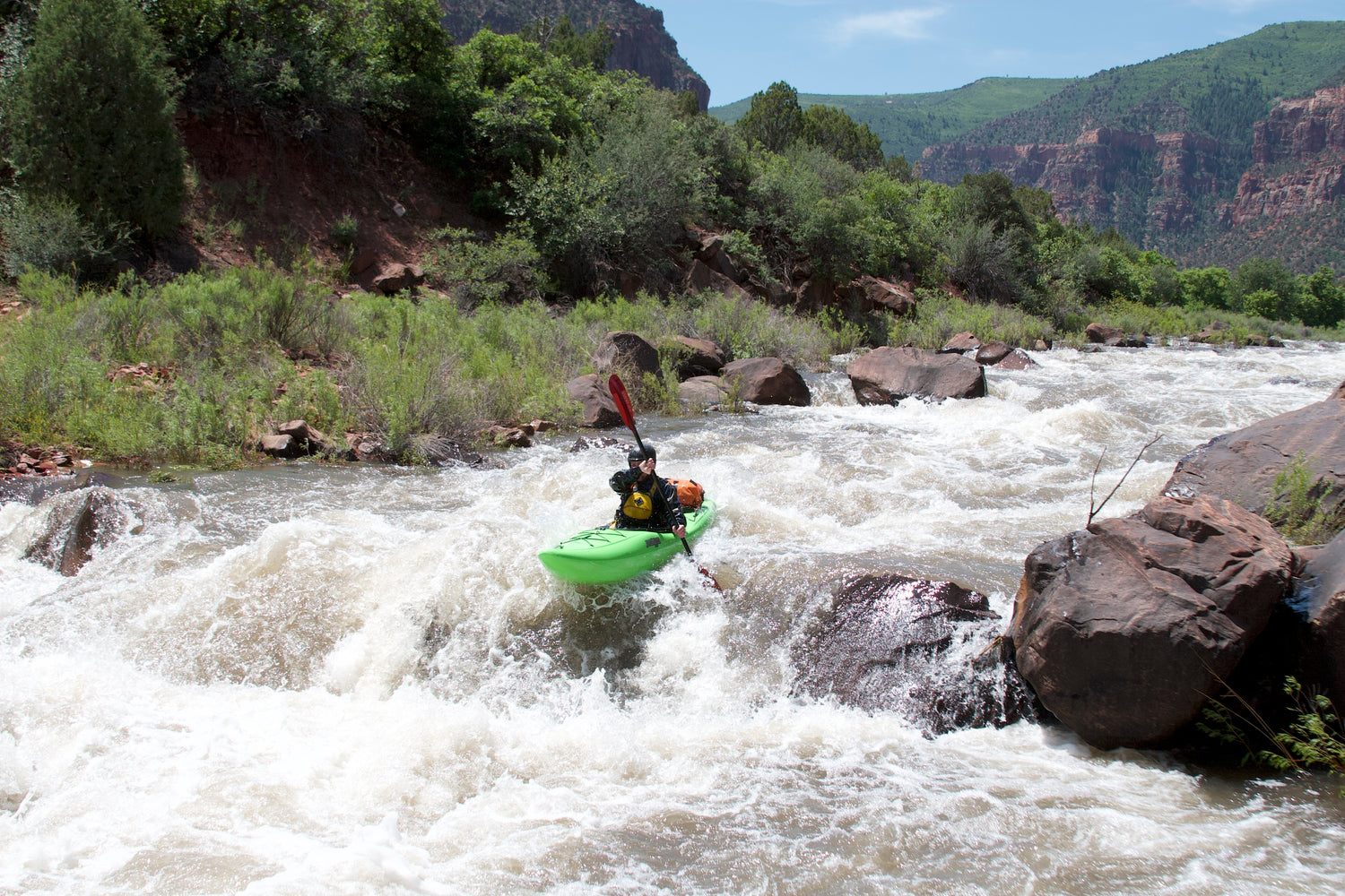
Stateline (or Chicken Raper) Rapid is a LONG, bony Class IV that sneaks up on you. Multiple lines exist, but this rapid is very continuous for over a mile. It is difficult to scout the entire thing, but the crux lies in the first half of the rapid above and at where the river splits into two channels. River right is the traditional line, but a river left line also exists. Be sure to scout thoroughly regardless of which line you choose.
Below Stateline, the canyon narrows and becomes much more scenic. The camping on this stretch is few and far between and some of the best sites are about a mile or two below Stateline. In another mile or two comes the last rapid of the run: Rockfall. This rapid sneaks up on you VERY quickly, and is the site of most of the carnage on the river. This is a MUST SCOUT and is good to send a kayaker or two through first. This nasty pin spot has caused many an unplanned layover to get raft(s) unstuck off the fang rock.
Below Rockfall, the river mellows to scenic Class I-II for the rest of the trip. There are several Grand Canyon-quality hikes in the canyon below Rockfall, so plan on spending some time here. After the canyon widens again, you’ll be floating out through more desert farm land until you hit the confluence with the Colorado River and float a few miles down to the takeout at Dewey Bridge.
Gauge:
Upper Dolores
The Upper Dolores is a stark contrast to the lower canyons below McPhee. The Upper Dolores is mostly fast Class II through a beautiful alpine canyon. While there are few defined rapids on this upper stretch, its fast, continuous nature keeps it exciting. Be sure to be heads up for wood on this stretch. About half-way through the run is the only break from the characteristic fast boogie water, when the river flows over a series of sandstone ledges, known as the Stoner-Stampede Section, which forms great surf for kayakers. This is the only real defined series of rapids on this stretch, which can get big at flows over 2000cfs. Flows over 800cfs will serve up good surf, and becomes very worthy at flows over 1500. Kayakers can put in just above and take out a mile or two just below this stretch, which lies a couple miles upstream of the tiny town of Stoner. Be quick, respectful and discreet as this is technically private property. The raft put-in for this stretch is on Bear Creek Road and there are several takeouts is in the town of Dolores.
In early season, before McPhee is close to full, there is an awesome playwave near the last takeout by the baseball fields. There is also a short Class V creeky section just above the town of Rico.
Gauge: